
Why Accurate IP Geolocation Matters
Getting your network’s IP geolocation right is more important than you might think. It affects everything from user experience to compliance and security. Content providers often use IP geolocation to serve region-specific content (for example, streaming services may block or allow access based on your IP’s country) and to route users to the nearest servers for better performance. If your network’s IP addresses are mis-located, users might see wrong language content or face unnecessary content restrictions. Geolocation accuracy is also important for legal compliance – for instance, ensuring user data stays within certain jurisdictions – and for security, where IP-based location is used in fraud detection or access control. Incorrect geolocation can lead to serious frustrations: “We’re an ISP, and some video streaming platforms—like Netflix—won’t let our users log in because it thinks they’re in the wrong country.” Or: “Online services are showing our entire network as being located in a different country. There’s no single “master” IP-to-location database, but rather many third-party services and proprietary systems. Generally, it’s the responsibility of network engineers and operators to ensure that accurate location information for their IP ranges is submitted to and maintained across various third-party geolocation providers and platforms.
Popular IP Geolocation Providers and How They Work
A number of companies maintain IP geolocation databases that are used by websites and applications worldwide. Notable providers include MaxMind (developed the popular GeoIP2 and free GeoLite2 databases), IP2Location, DB-IP, IPinfo.io, and even Google’s geolocation service. These providers compile data from various sources: regional internet registry (RIR) whois info, user-submitted corrections, network latency measurements, and more. Each provider’s database can differ, which is why the same IP might show as different locations on different lookup sites. For example, some services might rely heavily on the address and country in WHOIS records, while others use network telemetry or third-party feeds.
MaxMind is one of the most widely used – many CDNs and sites use MaxMind’s data for geolocation. It offers country-, city-, and ISP-level data and provides a free GeoLite2 database (with slightly reduced accuracy) and a commercial GeoIP2 database with full coverage. IP2Location and DB-IP similarly offer tiered databases (free and paid) with different levels of detail. IPinfo.io is an API service that aggregates data from multiple sources and community contributions, updating daily. Google also uses IP geolocation internally (e.g. determining which country’s search results or content to show). Historically Google leveraged third-party data like MaxMind, but now Google maintains its own processes; if Google’s geolocation for your IP is wrong, it can affect how Google services interact with your traffic.
There are many other providers, but the key point is no single provider has 100% accurate data. Country-level accuracy is generally high in well-covered regions, but city-level accuracy can be hit-or-miss. It’s best to check your IP ranges on multiple services to get an audit of what each database currently says. This audit will guide you on which corrections are needed where.
Updating Geolocation Data in RIR (Whois) Records
The first place to ensure correct data is the RIR whois database for your IP address range. The five RIRs (ARIN, RIPE NCC, APNIC, AFRINIC, LACNIC) maintain public registration records of who holds each IP block. Geolocation providers routinely ingest these records as one input for their databases. By updating your whois information, you establish an authoritative record of your IP range’s country or coordinates, which many GeoIP providers will notice.
Key Whois fields to check/update: In RIR inetnum/inet6num records (which define an allocated or assigned IP range), pay attention to the “country” attribute, and any geolocation-specific fields such as “geoloc” (for latitude/longitude). The country: attribute is a two-letter ISO country code intended to indicate the country where the network is registered or used. Many geolocation services use this as a default country for the IP. If you have moved a network’s usage to a new country (e.g. acquired a block from another region), updating the country code in whois is essential. The organization’s postal address (city, state, ZIP) in the whois may also influence city-level guesses – some providers algorithmically use the org’s address if no better info is available.
RIPE NCC: In the RIPE Database, each ORG, inetnum (IPv4) or inet6num (IPv6) object can include a geoloc attribute for latitude/longitude coordinates. For example, if your IPv4 block is based in Berlin, Germany, you might set geoloc: 52.510885 13.3989367 which corresponds to that city. The RIPE DB also supports a dedicated geofeed attribute where you can link to a geolocation CSV file in the format defined in RFC 8805. Make sure the country: field on your inetnum is correct as well – RIPE requires at least one country attribute. You can include multiple countries if the network spans borders, but if the block is primarily used in one country, use that country code. All these changes can be made through RIPE Database updates, and they are effective immediately.
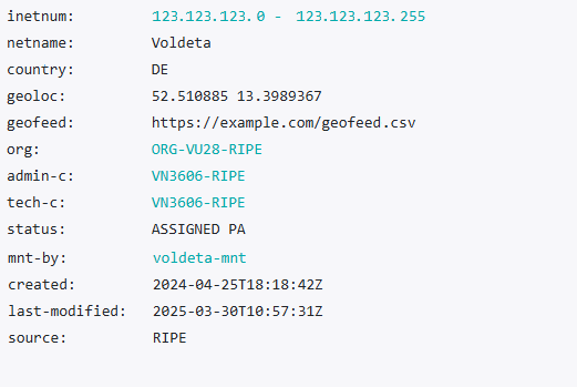
The Geolocation Setup Example in the RIPE Database
ARIN: ARIN’s Whois records (often called NET records) do not have explicit geolocation fields – ARIN does not maintain geolocation data for IP addresses. The focus for ARIN regions is to ensure your Org and network registration info are accurate. Check that the Org’s address and postal code reflect the location of the network’s operation if possible. For IP blocks delegated by ARIN, you might have to use SWIP (Shared Whois Project) or ARIN’s RWhois to specify customer reassignment information for downstream users. For example, if you’re an ISP assigning part of your block to a customer in another country or state, submit a SWIP so that the customer’s name and address (including country) are listed – otherwise the block might appear to be located at your company’s HQ address. While ARIN doesn’t verify geolocation, geolocation providers do parse ARIN’s Whois data; having the correct city and country in the Org/NET records can influence their data. In ARIN’s database, the top-level NET record usually inherits the Org’s country by default (e.g. country of the organization holding the block). If that’s misleading, consider registering a new Org ID in ARIN for the network’s actual operating location, and transferring or reallocating the network to that Org. Additionally, ARIN’s IRR (Internet Routing Registry) can be used to publish geofeed info indirectly: ARIN doesn’t support inetnum objects or native geofeed fields, but you can add a remark in a route object, e.g. remarks: Geofeed https://example.com/geofeed.csv, as a workaround. This technique is less straightforward, but some geolocation providers scan IRR data too.
APNIC: APNIC’s whois is very similar to RIPE’s. inetnum/inet6num records have a mandatory country code and optional geoloc attribute as well. APNIC has officially implemented geofeeds attribute: you can log into MyAPNIC and for each IP range object, add a Geofeed. APNIC’s interface provides a drop-down to add “geofeed” and a text box for the URL . Once you update, APNIC will publish the geofeed URL as part of your whois record (available to anyone querying). As with RIPE, keep the country code accurate (APNIC will by default set it to the account holder’s country, but you can change it if the usage is elsewhere). If you serve IPs in multiple countries (common in APNIC region networks), you might list the broad region or principal country in the whois, but rely on the geofeed CSV for per-prefix detail.
Other RIRs like LACNIC and AFRINIC have similar whois schemas (country attributes, etc.) and have introduced support for geofeed remarks or fields in recent years. The best practice everywhere is: ensure your whois records reflect reality – correct country codes, up-to-date contact addresses, and use any location fields available.
Creating and Utilizing Geofeed Files (RFC 8805)
Network operators can publish an authoritative mapping of their IP prefixes to locations by using Geofeeds, as defined in RFC 8805. A geofeed file is simply a CSV (comma-separated values) file hosted on your web server (HTTPS accessible) that lists each prefix and the intended location data. The format is straightforward: each line contains an IP prefix, an ISO 3166-1 country code, and optionally region (ISO 3166-2), city, and postal code. At minimum, each entry should have the prefix and country. Region and city are optional but can greatly improve accuracy for city-level databases – and note that some providers (like IP2Location) will only accept your geofeed if all entries include a city. If you’d prefer not to create Geofeed lines and files manually, you can use a free service like PacketVis to generate the CSV file.
How to set up a geofeed: Create the CSV file with all your IPv4 and IPv6 blocks, listing the appropriate location for each. Then host this file on a stable URL (it must be HTTPS). You might host it on your own website or even a public GitHub gist (as long as the URL is under your control). Next, publish the geofeed’s URL via the RIR whois. In RIPE or APNIC, this means adding the geofeed: attribute to the inetnum/inet6num object (or as a remarks: Geofeed https://... if a dedicated field isn’t available). In ARIN’s case, since you cannot add it to NET directly, you can use an IRR route object remark as mentioned, or simply share the URL with geolocation providers manually. By adding it to whois, you enable auto-discovery: some geolocation providers periodically scan RIR databases for new geofeed references.
Benefits of geofeeds: It provides one authoritative source for your IP-to-location data that you can update anytime (much easier than filing individual requests with dozens of companies). It’s also security-verified to an extent – APNIC, for instance, only allows the resource holder to add the geofeed URL via the portal, giving geolocation providers confidence that the feed is authentic. Geofeeds significantly simplify data maintenance: instead of waiting weeks for various databases to update, you can push out a new CSV line whenever you deploy IPs in a new city. This mechanism benefits geolocation providers too, as they gain access to up-to-date, operator-published data.
Will geofeed data actually be used? As of now, many major GeoIP providers have started integrating geofeed support. For example, MaxMind, IPinfo, DB-IP, and Google all listen for geofeed data published in RIR registries. Google even provides an ISP portal (isp.google.com) where network owners can input a geofeed URL directly with Google – indicating Google’s systems will then fetch your CSV for their geolocation services. Other companies like Digital Element are also on board (they have their own portals or contacts for submitting geofeeds or bulk data). However, not every provider automatically checks geofeeds yet; some still rely on manual reports. The best practice is to set up a geofeed and also proactively inform providers from the table below that it exists. Once your geofeed is live, you can validate its format with tools like opengeofeed.org’s validator to ensure there are no syntax errors. Keep the file updated as your network grows or changes, and keep the whois reference accurate if the URL changes.
Contacting Geolocation Providers and Specific Service Providers for Updates
Even with perfect whois records and a published geofeed, you may need to contact geolocation providers directly, especially if your IP range is currently mis-located in their database and you need a quicker fix. Most providers have a process for network owners to submit corrections or update requests. Below is a summary of major geolocation providers, and how to request an update. In the Notes section, whenever we know which geo service is used by a major digital service provider, we’ve specified it and included a link to the source confirming this information:
| Provider | How to Request Geolocation Update | Notes |
|---|---|---|
| MaxMind (GeoIP) | Use the GeoIP correction form on MaxMind’s site. You can submit the IP range, correct location, and supporting info. | MaxMind updates typically propagate in the next database release, which occurs every Tuesday and Friday. Viaplay, Cloudflare, Amazon Cloudfront, use Maxmind Geo Lookup to detect the IPv4 address geolocation. |
| IP2Location | Email support@ip2location.com or use their contact form. | A requester may need to prepare an affidavit or a sworn statement in writing with the following information:(a) name of the requester and the company he or she represents (b) IP address or IP address ranges that he or she owns or want to update (c) changes requested (d) sign the statement in front of a notary public or commissioner of oaths and seal it. |
| DB-IP | Submit via their contact form or email support@db-ip.com. Provide the IP range and the correct country/city. | DB-IP is known to pull data from RIR records and geofeeds, but direct contact can expedite fixes. They update their database daily for API users. |
| IP-API | Submit IP Data Correction Request via their contact form | They manually verify all requests and the geolocation update process may take up to 7 days. |
| IPinfo.io | Use the IPinfo corrections form for one-off fixes. For bulk changes, IPinfo prefers you publish a geofeed (they actively consume geofeed data). | If you manage many prefixes, set up a geofeed and then notify IPinfo so they can ingest it regularly. |
For Google’s services (like search, YouTube) you can report incorrect IP location using Google’s IP feedback form. Network operators can also use Google’s ISP portal at isp.google.com to set a geofeed (requires account approval) | Google doesn’t publish its own GeoIP DB publicly, but correcting Google’s view is important for user-facing products. Changes may take effect after Google verifies and updates their internal data. | |
| Digital Element | Digital Element accepts requests via their contact form. You can also try to reach them using the following email: ip-data@digitalelement.com | These providers supply data to many streaming services and enterprises. Provide evidence of the IP’s new location (whois info, etc.) in your request. They may have slower update cycles but are critical for things like streaming platforms. Disney uses Digital Element to detect the IP address geolocation. |
| IPGeolocation | Use the following form or send a email to support@ipgeolocation.io. Bulk corrections via Geofeeds (they actively consume geofeed data). | If you manage multiple prefixes, set up a geofeed and then notify them. |
| IPData | To correct the geolocation of IP addresses that you own or operate, please send a geofeed to support@ipdata.co | |
| Netflix | To update IP address geolocation in Netflix, follow their instructions here. If this doesn’t help, try to contact geosupport@netflix.com |
Finally, if a particular web service or application is still showing the wrong location even after the major databases have been updated, you may need to reach out to that service directly. Some large content providers (like Netflix) have their own geolocation mechanisms or caching intervals. For instance, Netflix advises ensuring RIR records are correct, and if issues persist, they have a dedicated geolocation support email. Check the documentation or support forums of the specific service for IP geolocation correction procedures.
By following the steps above – updating registry info, publishing a geofeed, and notifying key databases – you’ll greatly improve the accuracy of your network’s geolocation across the internet. This ensures users, customers, and services see your IPs in the right place, reducing problems with content access and security checks.
Author: Anastasia Kleiman.